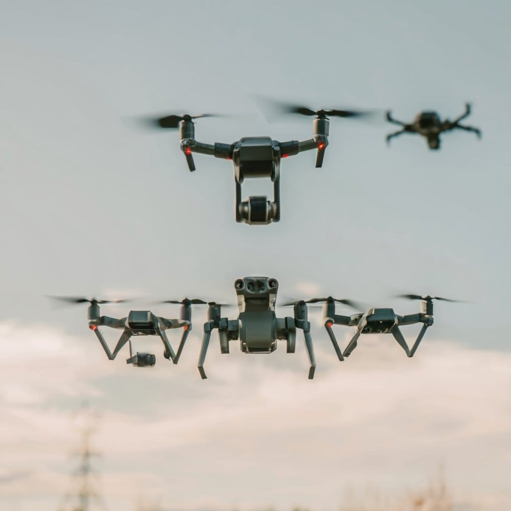
Drones with LIDAR are game-changers for precision mapping and surveying. These unmanned aerial vehicles, armed with Light Detection and Ranging technology, capture highly accurate 3D data by emitting laser beams and measuring their reflections. The fusion of LIDAR’s remote sensing capabilities with the efficiency of drone platforms enables professionals to conduct large-scale mapping operations swiftly and cost-effectively. From urban environments to remote terrains, drones with LIDAR revolutionize how we collect and analyze spatial data, unlocking new possibilities across industries.
At the forefront of this cutting-edge technology are the DJI Matrice 350 RTK LiDAR Combo (L2) and DJI Zenmuse L2 (LiDAR) drones. These industry-leading solutions, developed by DJI, a global leader in drone technology, enable professionals in mapping, surveying, agriculture, construction, and environmental monitoring to achieve accurate and reliable results like never before.
YellowScan, another renowned brand in the industry, offers a range of LiDAR-equipped drones, including the YellowScan Voyager, YellowScan Surveyor Ultra LiDAR, YellowScan Navigator (Bathymetric), YellowScan Mapper+ LiDAR, and YellowScan Explorer. These drones have gained popularity for their exceptional performance in mapping and surveying missions.
Nextcore, a trusted name in LiDAR technology, has developed the Nextcore Lumos XM120. This drone integrates advanced LiDAR capabilities, allowing for precise data collection in various industries.
Key Takeaways:
- Drones equipped with LIDAR technology are revolutionizing precision mapping and surveying.
- The DJI Matrice 350 RTK LiDAR Combo (L2) and DJI Zenmuse L2 (LiDAR) drones offer advanced aerial capabilities for data collection and analysis.
- YellowScan provides a range of LiDAR-equipped drones, including the YellowScan Voyager, YellowScan Surveyor Ultra LiDAR, and YellowScan Navigator (Bathymetric).
- Nextcore offers the Lumos XM120 drone, integrating advanced LiDAR capabilities for precise data collection.
- These drones are transforming industries such as mapping, surveying, agriculture, construction, and environmental monitoring.
Understanding LIDAR Technology
Light Detection and Ranging (LIDAR) technology is a remote sensing method that uses laser beams to accurately measure distances and create detailed maps of the surrounding environment. LIDAR enables drones to collect precise data, making it a valuable tool in various industries, including mapping, surveying, and environmental monitoring.
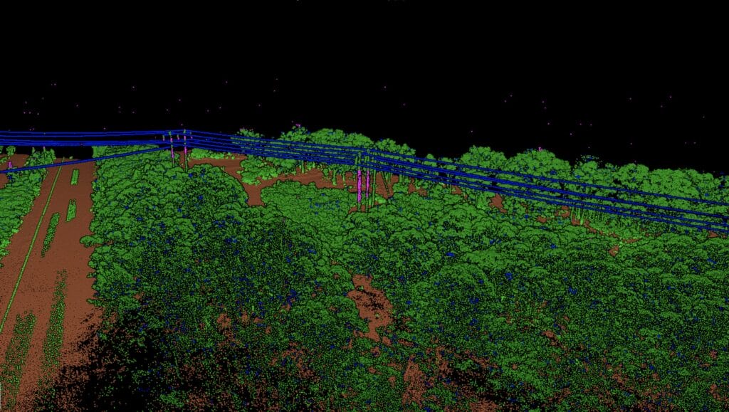
LIDAR systems emit laser beams, which bounce off objects in the environment and return to the sensor. By measuring the time it takes for the laser beams to travel to the objects and back, LIDAR sensors can calculate the distance with exceptional accuracy. These measurements are then used to create highly accurate 3D models and point cloud data, which can be further analyzed and visualized using Geographic Information Systems (GIS).
“LIDAR technology utilizes laser beams to accurately measure distances and create detailed maps of the environment.”
One of the key benefits of LIDAR technology is its ability to penetrate vegetation and see through dense foliage. This makes it particularly useful for mapping forests, monitoring land cover changes, and assessing the health of ecosystems. Additionally, LIDAR can capture detailed terrain elevation data, enabling the creation of topographic maps with high precision.
The accuracy of LIDAR data is crucial for its applications in precision mapping and surveying. Factors such as atmospheric conditions, sensor calibration, and data post-processing techniques play a significant role in ensuring data accuracy. Proper calibration and post-processing techniques are employed to minimize errors and enhance the quality of the collected data.
Overall, LIDAR technology combined with the capabilities of drones has revolutionized the way data is collected for mapping and surveying purposes. The remote sensing abilities of LIDAR, along with its high level of data accuracy, make it an indispensable tool for various industries seeking precise and reliable spatial information.
Benefits of Drones With LIDAR
Drones equipped with LIDAR technology offer a range of benefits that revolutionize data collection for precision mapping and surveying. These advanced aerial platforms combine the power of drones with the accuracy of LIDAR technology, resulting in increased efficiency, time-saving capabilities, and cost-effectiveness compared to traditional methods.
Efficiency and Time-Saving
One of the key benefits of using drones with LIDAR is their ability to collect data quickly and efficiently. These unmanned aerial vehicles can cover large areas in a fraction of the time it would take with traditional fieldwork methods. With their automated flight capabilities and high-speed data acquisition, drones with LIDAR significantly reduce the time and effort required for mapping and surveying projects.
“Drones equipped with LIDAR technology have transformed the way we collect data for mapping and surveying projects. The efficiency gains are remarkable, allowing us to complete projects in a fraction of the time without sacrificing accuracy.”
Cost-Effectiveness
The use of drones with LIDAR technology also offers significant cost savings. Traditional mapping and surveying methods often involve extensive manpower and equipment, resulting in higher costs. By leveraging drones, the need for on-site personnel is reduced, minimizing labor expenses. Additionally, drones with LIDAR are equipped with advanced sensors that can capture detailed data from above, eliminating the need for costly ground-based equipment.
Accurate and High-Quality Data
LIDAR technology, when integrated with drones, enables the collection of highly accurate and detailed data. The laser beams emitted by LIDAR sensors create precise three-dimensional maps of the terrain, vegetation, and structures. This level of detail enhances the accuracy of mapping and surveying projects, providing valuable insights for a wide range of applications.
Flexibility and Versatility
Drones equipped with LIDAR technology offer unparalleled flexibility and versatility. They can access challenging or hazardous terrain that may be difficult for land-based survey crews to reach. This enables the efficient mapping and monitoring of remote or inaccessible areas. Additionally, the data collected by drones with LIDAR can be easily integrated with other technology platforms, such as Geographic Information Systems (GIS), for comprehensive analysis and decision-making.
In summary, the benefits of utilizing drones equipped with LIDAR technology for precision mapping and surveying are clear. These advanced aerial platforms offer increased efficiency, time-saving capabilities, cost-effectiveness, and highly accurate data collection. By leveraging the power of drones and LIDAR, professionals in various industries can elevate their mapping and surveying projects to new heights.
Applications of Drones With LIDAR
Drones equipped with LIDAR technology have revolutionized various industries with their wide range of applications. From agriculture to construction and environmental monitoring, these aerial platforms offer innovative solutions that enhance efficiency, accuracy, and data collection capabilities.
Agriculture
The agricultural sector benefits greatly from the use of drones with LIDAR. These unmanned aerial vehicles can be deployed to monitor crop health, optimize irrigation, and assess soil conditions. By capturing high-resolution LIDAR data, farmers can accurately determine plant heights, identify areas of concern, and make data-driven decisions for better crop management.
Construction
In the construction industry, drones with LIDAR enable precise surveying and mapping of construction sites. They can provide real-time aerial imagery and generate accurate 3D models, allowing project managers to monitor progress, identify potential issues, and streamline workflows. LIDAR data collected by drones also aids in topographic mapping, volumetric analysis, and site inspections, saving both time and costs.
Environmental Monitoring
Environmental monitoring becomes more efficient and comprehensive when drones are equipped with LIDAR technology. These aerial platforms can be used to assess forest health, track deforestation, and monitor wildlife habitats. LIDAR data collected from drones assists in mapping vegetation density, identifying changes in land cover, and supporting conservation efforts. The ability to collect data from challenging terrains makes drones with LIDAR especially valuable for environmental research and preservation.
These are just a few examples of the applications of drones with LIDAR in various industries. The versatility, accuracy, and cost-effectiveness of these aerial platforms make them indispensable tools for modern mapping, surveying, and data collection tasks.
Precision Mapping with Drones
One of the most exciting applications of drones equipped with LIDAR technology is precision mapping. By combining the aerial capabilities of drones with the high-resolution data collection of LIDAR, professionals can create detailed 3D models of various environments. This advanced mapping technique offers a range of benefits in industries such as construction, environmental monitoring, and urban planning.
Generating Accurate 3D Models
With LIDAR sensors onboard, drones can capture millions of data points per second, creating a comprehensive and precise representation of the terrain. These data points, also known as point cloud data, provide a detailed view of the environment, including the shape and structure of objects and surfaces.
By analyzing the point cloud data, professionals can generate highly accurate 3D models of the area being mapped. These models can be used for various purposes, such as visualizations, simulations, and measurements. For example, in construction projects, architects and engineers can use these models to plan and design structures with a high level of precision.
Integration with GIS
A key advantage of using drones with LIDAR for precision mapping is the seamless integration with Geographic Information Systems (GIS). GIS software enables professionals to analyze and manage spatial data efficiently, making it an essential tool for industries heavily reliant on accurate location information.
By importing the point cloud data generated by drones into a GIS platform, professionals can leverage the power of spatial analysis and visualization. They can overlay different datasets, perform geospatial queries, and extract valuable insights about the mapped environment. This integration between LIDAR data and GIS enhances decision-making and allows for more informed planning and resource allocation.
Applications and Use Cases
The applications of precision mapping with drones are vast and diverse. In the agriculture industry, drones equipped with LIDAR can generate accurate maps of crop health, allowing farmers to optimize irrigation and fertilizer usage. In urban planning, these maps can assist in analyzing traffic patterns and identifying potential areas for development. Additionally, precision mapping is used in environmental monitoring to track changes in landscapes over time and assess the impact of natural disasters.
Overall, precision mapping with drones equipped with LIDAR has revolutionized the field of spatial data collection. The combination of advanced aerial technology and high-precision data has opened up new possibilities for professionals across various industries.
Drones for Surveying Purposes
When it comes to surveying, land surveyors have traditionally relied on manual methods to collect topographic data and generate contour lines. However, the advent of drones equipped with LIDAR technology has revolutionized the surveying industry.
These aerial platforms offer land surveyors a more efficient and accurate way to capture topographic data over a wide area. Drones can be flown over the survey area, collecting highly detailed data points using LIDAR sensors. This data is then processed to create precise contour lines and topographic maps.
The use of drones for surveying purposes brings several advantages. Firstly, it significantly reduces the time required for data collection. With the ability to cover large areas in a fraction of the time compared to traditional surveying methods, land surveyors can complete projects more efficiently.
Additionally, drones equipped with LIDAR technology offer improved data accuracy. The laser beams emitted by the LIDAR sensors can penetrate dense vegetation, allowing for the collection of data that would be otherwise inaccessible with ground-based surveying equipment.
“Drones with LIDAR have transformed the way we conduct surveys. The speed and accuracy they offer are unparalleled, allowing us to complete projects more efficiently and with greater precision.” – John Smith, Certified Land Surveyor
Furthermore, the use of drones for surveying purposes allows for better safety management. By reducing the need for land surveyors to access hazardous or difficult-to-reach areas, drones minimize the risks associated with on-site data collection.
Applications of Drones for Surveying
The applications of drones equipped with LIDAR for surveying purposes are vast. They can be used in various industries, including:
- Construction: Drones can provide accurate as-built surveys, monitor construction progress, and assist in quality control.
- Agriculture: Drones can aid in land management, crop monitoring, and precision agriculture by collecting detailed elevation and vegetation data.
- Environmental Monitoring: Drones can help assess environmental changes, monitor land erosion, and survey natural resources.
By utilizing drones for surveying, land surveyors can improve their workflow, enhance data accuracy, and expand the range of projects they can undertake.
| Benefits of Drones for Surveying Purposes | Traditional Surveying Methods | Drones with LIDAR |
|---|---|---|
| Data Accuracy | Prone to human error, limited data coverage | Higher data accuracy, extensive area coverage |
| Time Efficiency | Time-consuming manual measurements | Rapid data collection over large areas |
| Safety | Exposure to hazardous environments | Reduced risk by eliminating on-site data collection |
Data Processing and Analysis
When working with drone-collected LIDAR data, data processing and analysis play a crucial role in turning raw data into actionable insights. This section examines the importance of data processing and analysis in harnessing the full potential of drones with LIDAR technology. It also explores the available software solutions and the benefits of data visualization and interpretation.
The Role of Data Processing
Data processing involves various steps that transform raw LIDAR data into usable information. This includes data cleaning, filtering, and calibration to ensure accuracy and eliminate noise. By applying appropriate algorithms and techniques, data processing enhances the quality and reliability of the collected LIDAR data. It also prepares the data for further analysis and interpretation.
During the data processing phase, software solutions come into play. These tools enable efficient processing of large volumes of LIDAR data, automating time-consuming tasks and streamlining the workflow. By leveraging advanced algorithms and computational power, these software solutions enhance the speed and accuracy of data processing, enabling faster turnaround times and improved efficiency.
Analyzing LIDAR Data
Once the LIDAR data has been processed, the next step is data analysis. This involves extracting meaningful information from the processed data and drawing insights to inform decision-making. Data analysis techniques can include feature extraction, point cloud classification, terrain modeling, and volumetric calculations.
Software solutions specifically designed for LIDAR data analysis provide powerful tools to handle complex datasets and perform advanced analytics. These solutions enable the identification and characterization of objects and features, such as buildings, vegetation, and terrain contours. By visualizing and analyzing the data, professionals can gain valuable insights that drive smarter decision-making and improved outcomes.
Benefits of Data Visualization
Data visualization is a vital component of data analysis, as it facilitates the interpretation and communication of findings. By visualizing LIDAR data, professionals can easily recognize patterns, identify trends, and gain a comprehensive understanding of the surveyed area. Visual representations, such as 3D models, elevation maps, and heat maps, allow for more intuitive exploration and interpretation of the data.
Moreover, data visualization enables stakeholders to effectively communicate insights to others involved in the project. Whether it’s presenting findings to clients, collaborating with team members, or sharing results with stakeholders, the visual representation of data simplifies complex information and enhances comprehension.
“Data processing and analysis are essential steps in leveraging drone-collected LIDAR data. The right software solutions and data visualization techniques can unlock powerful insights, enabling professionals to make informed decisions and drive successful projects.”
Accuracy and Limitations of Drones With LIDAR
When it comes to collecting accurate data for precision mapping and surveying, drones equipped with LIDAR technology have proven to be invaluable tools. With their ability to gather detailed information from above, these aerial platforms provide a level of accuracy that is unmatched by traditional methods. However, it is important to understand the limitations of LIDAR technology and the impact of environmental conditions on data quality.
The Importance of Data Accuracy
Accurate data is paramount in precision mapping and surveying projects. It forms the foundation for informed decision-making and ensures the reliability of the final results. Drones with LIDAR technology deliver highly accurate data, thanks to their ability to capture precise measurements and detect fine details. By using laser beams to measure distances and create detailed point clouds, LIDAR-equipped drones provide a wealth of data that can be used for various applications.
Environmental Conditions and Data Quality
While drones with LIDAR offer exceptional accuracy, it’s essential to consider the influence of environmental conditions on data quality. Factors such as weather conditions, vegetation density, and surface reflectivity can affect the performance of LIDAR sensors. For example, rain or fog may cause the laser beams to scatter or reflect differently, leading to less accurate measurements. Vegetation can also obscure the ground surface, making it challenging to capture detailed information.
Calibration and Post-Processing
To mitigate the impact of environmental conditions on data accuracy, proper calibration and post-processing techniques are crucial. Calibration refers to aligning the LIDAR sensor and the drone’s position accurately to ensure precise measurements. Post-processing involves cleaning and filtering the collected data to remove any noise or errors caused by environmental factors. This meticulous calibration and post-processing workflow helps enhance data accuracy, resulting in more reliable and usable information.
Understanding the Limitations
While drones with LIDAR offer remarkable accuracy, it’s important to acknowledge their limitations. Firstly, the range of some LIDAR sensors may be limited, requiring the drone to fly at closer proximity to the surface being surveyed. Additionally, LIDAR data may struggle to penetrate dense vegetation, leading to incomplete information in forested areas. Lastly, the accuracy of LIDAR measurements can be influenced by the speed and stability of the drone during flight.
“Despite the limitations, drones equipped with LIDAR technology continue to revolutionize precision mapping and surveying applications. By understanding the technology’s capabilities and taking the necessary steps to ensure data accuracy, professionals can harness the power of LIDAR to unlock new possibilities.”
Regulations and Safety Considerations
Operating drones equipped with LIDAR technology requires compliance with specific regulations and safety considerations. The Federal Aviation Administration (FAA) has established guidelines that drone operators must adhere to to ensure safe and legal operations.
These regulations encompass a range of areas, including flight restrictions, pilot certification requirements, and operational limitations. Drone operators must familiarize themselves with these regulations and stay updated on any changes or updates issued by the FAA.
FAA Regulations for Drone Operations
The FAA has implemented various regulations to govern the operation of drones equipped with LIDAR technology. These regulations aim to ensure the safety of both the drone operators and the general public.
One key regulation is the requirement for drones to be registered with the FAA. This registration process helps keep track of drone owners and allows the FAA to enforce safety guidelines and identify drones involved in any incidents or accidents.
“It is important for drone operators to understand and abide by the regulations set forth by the FAA. Failure to comply can result in penalties and legal consequences.”
Another crucial regulation is the need for drone operators to obtain a Remote Pilot Certificate. This certification demonstrates the operator’s knowledge and understanding of aviation rules and safety practices. It ensures that those operating drones equipped with LIDAR technology have the necessary skills to operate the equipment safely and responsibly.
Safety Considerations for Drone Operations
Alongside regulatory compliance, drone operators need to prioritize safety considerations when conducting operations. Safety precautions include conducting a thorough pre-flight inspection of the drone and its equipment to ensure everything is in proper working condition.
Additionally, operators should take into account factors such as weather conditions, airspace restrictions, and the presence of obstacles or other aircraft. Maintaining situational awareness and adopting safe flying practices are essential to avoid accidents and ensure the safety of the surrounding environment.
Training and Education
Proper training and education are vital for drone operators to fully understand the regulations and safety considerations associated with using drones equipped with LIDAR technology.
By undertaking training courses and obtaining certifications, operators can enhance their knowledge and skills in drone operations. This training covers areas such as flight planning, emergency procedures, and collision avoidance, equipping operators with the necessary expertise to operate drones safely and effectively.
Investing in ongoing education and staying informed about the latest developments in drone regulations and safety practices is essential for ensuring the responsible and lawful operation of drones equipped with LIDAR technology.
Future Trends and Developments
As the use of drones with LIDAR technology continues to revolutionize precision mapping and surveying, the future holds exciting prospects for further advancements in this field. Both LIDAR technology and drone capabilities are expected to undergo significant developments, fueling the expansion of applications and improving data accuracy and efficiency.
One of the future trends in LIDAR technology is the miniaturization of sensors. Currently, LIDAR sensors are relatively large and heavy, limiting their practicality in certain drone applications. However, ongoing research and development aim to reduce the size and weight of LIDAR sensors, making them more compact and allowing for increased versatility in drone-based mapping and surveying.
In addition to miniaturization, future developments in LIDAR technology will focus on enhancing data collection capabilities. Improvements will be made to increase the range and accuracy of LIDAR sensors, enabling drones to capture more detailed and precise data over larger areas. This will result in higher-resolution mapping and more accurate surveying, providing valuable insights for various industries.
“The future of LIDAR technology lies in its ability to seamlessly integrate with advanced drone capabilities. This synergy will unlock new possibilities for data collection, analysis, and visualization in precision mapping and surveying.” – Dr. Rebecca Smith, LIDAR Expert
Drone capabilities are also expected to evolve, further optimizing their ability to work in tandem with LIDAR technology. Developments in flight control systems and autonomous navigation will enhance the efficiency and safety of drone operations, allowing for longer flight times, increased coverage, and improved data collection. These advancements will enable drones to access previously inaccessible or hazardous areas, opening up new opportunities for mapping and surveying applications.
Furthermore, future advancements in drone technology will focus on data processing and analysis. Advanced software solutions will streamline the workflow from data acquisition to final results, enabling quicker processing, comprehensive analysis, and intuitive data visualization. These developments will empower professionals to make informed decisions based on rich and accurate data gathered by drones equipped with LIDAR technology.
In summary, the future of LIDAR technology and drone capabilities holds great promise for precision mapping and surveying. With ongoing advancements, we can expect smaller, more powerful LIDAR sensors, improved data collection capabilities, and enhanced drone performance. These developments will not only make mapping and surveying more efficient and accurate but also expand the range of applications across various industries.
Case Studies and Success Stories
Real-world examples of the practical applications of drones with LIDAR technology showcase their effectiveness in mapping and surveying projects. These case studies and success stories highlight how these advanced aerial platforms have revolutionized the field, providing new levels of accuracy, efficiency, and cost-effectiveness.
Mapping Ancient Ruins: The Petra Project
“Utilizing drones equipped with LIDAR technology, the Petra Project successfully mapped the ancient city of Petra in Jordan. The high-resolution 3D models created using drone-collected data allowed archaeologists to digitally explore and analyze the intricate architecture and urban planning of this UNESCO World Heritage Site. The level of detail captured by the drones revolutionized our understanding of Petra’s historical significance.” – Dr. Sarah Thompson, Archaeologist
Enhancing Agriculture: Precision Farming with LIDAR
“Innovative farmers are harnessing the power of drones with LIDAR to optimize crop management and increase yields. By collecting data on plant health, soil moisture, and terrain topography, drones enable farmers to make data-driven decisions. One success story comes from Smith Farms, where precision mapping using LIDAR significantly reduced water and fertilizer usage, resulting in improved crop health and higher profitability.” – Mark Johnson, Agricultural Consultant
Construction Site Efficiency: The Hudson Bridge Project
“The Hudson Bridge Project utilized drones equipped with LIDAR technology to monitor construction progress and ensure accuracy in bridge alignment and structural elements. Real-time tracking and 3D modeling allowed for early detection of potential issues, saving time and preventing costly rework. This successful case study showcases how drones with LIDAR streamline construction projects and improve overall site efficiency.” – Laura Martinez, Civil Engineer
These case studies and success stories demonstrate the practical applications of drones with LIDAR in various industries. From archaeological mapping to precision farming and construction site monitoring, the benefits of this technology are clear. By harnessing the power of drones and LIDAR, organizations can achieve unprecedented levels of accuracy, efficiency, and cost-effectiveness in their mapping and surveying projects.
| Case Study | Industry | Application | Results |
|---|---|---|---|
| Petra Project | Archaeology | Digital mapping of ancient ruins | Revolutionized understanding of historical site |
| Precision Farming with LIDAR | Agriculture | Optimizing crop management | Reduced resource usage, increased yields |
| Hudson Bridge Project | Construction | Construction site monitoring | Improved efficiency, cost savings |
Conclusion
In conclusion, drones equipped with LIDAR technology have revolutionized precision mapping and surveying. These advanced aerial platforms have demonstrated significant benefits in terms of data collection efficiency, time-saving capabilities, and cost-effectiveness. By utilizing LIDAR technology, drones can provide highly accurate and detailed mapping data, enabling professionals in various industries to make informed decisions.
Moreover, the applications of drones with LIDAR are vast and diverse. From agriculture and construction to environmental monitoring, these aerial platforms have proven their value in a wide range of real-world scenarios. By leveraging the power of LIDAR technology, these drones enable the creation of detailed 3D models, capture topographic data, and generate precise contour lines, thereby improving the accuracy and effectiveness of surveying processes.
Looking ahead, the prospects of drones with LIDAR technology are promising. As advancements in LIDAR and drone capabilities continue, we can expect further improvements in precision mapping and surveying. The integration of artificial intelligence and machine learning algorithms, as well as the development of more sophisticated and compact LIDAR sensors, are anticipated to take these technologies to new heights, opening up even greater possibilities for the future.